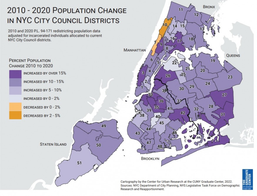
2010-2020 Population Change in New York City Council Districts Source: Center for Urban Research, CUNY Graduate Center
July 18, 2022 By Czarinna Andres
The council districts in western Queens will be undergoing significant change if the preliminary maps released by the NYC Districting Commissioner on Friday are to go into effect.
The commission released the preliminary maps for all 51 council districts, which aim to reflect the population changes reported in the 2020 U.S. census. The districts are redrawn every 10 years—following each U.S. census—in accordance with the New York City Charter.
The final maps will determine the districts for the 2023 city council races and must be filed with the City Clerk no later than Feb. 7, 2023.
Council District 26–which currently incorporates Sunnyside, Woodside, Long Island City and parts of Astoria—would undergo significant change if the maps were to go into effect.
The new District 26 map would see much of Astoria removed—along with Queensbridge and Ravenswood—and folded into District 22. Most of Woodside would also be gone, with portions of it falling into District 30 and District 25.
The 26th district, however, would incorporate parts of Manhattan. It would include Roosevelt Island and the Upper East Side of Manhattan in proximity to the Queensboro Bridge.
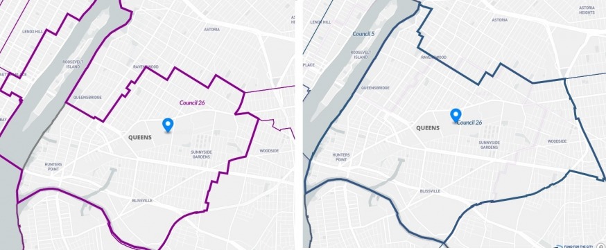
The draft map for Council District 26 (left) with the existing district map on the right. The new map would include Roosevelt Island and a section of the Upper East Side of Manhattan (Source: redistrictingandyou.org)
The ethnic makeup of the revised 26th Council District would undergo major change. The redrafted district would be approximately 44 percent white non-Hispanic; 25 percent Asian; 22 percent Hispanic; and 4 percent Black, based on 2020 census data tabulated by the public service website Redistricting & You.
If the existing map were to remain unchanged, the population makeup—based on 2020 Census data– would be 29 percent white non-Hispanic; 31 percent Asian; 29 percent Hispanic; and 6 percent Black.
Changes were inevitable to the 26th Council District since the population of the district increased by more than 15 percent between 2010 and 2020—to 183,926—and each district is required to be approximately 172,882.
Meanwhile, District 22—which currently covers most of Astoria as well as East Elmhurst—would not undergo as much change, although it would cover a greater portion of Astoria and would include Queensbridge Houses and Ravenswood.
The 22nd district was determined to have 159,611 residents at the time of the 2020 U.S. census and needed to be enlarged given its smaller population size.
The change would not see a major shift in the ethnic makeup of the district. The revised district would be 45 percent white non-Hispanic; 28 percent Hispanic; 14 percent Asian and 8 percent Black. The existing district map, based on 2020 U.S. census data, would be 49 percent white non-Hispanic; 27 percent Hispanic; 15 percent Asian; and 5 percent Black.
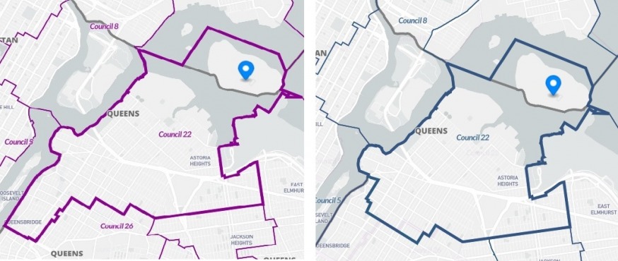
The draft map for Council District 22 (left) with the existing district map on the right. The new map would include Queensbridge and Ravenswood (Source: redistrictingandyou.org)
The 25th District—which currently covers Jackson Heights and Elmhurst—would see very little change, except for the addition of a few blocks in Woodside. The demographics would also remain almost identical.
The revised district would be 44 percent Asian; 41 percent Hispanic; 11 percent white non-Hispanic; and 2 percent black. The existing map—based on 2020 census data– would be 44 percent Asian; 42 percent Hispanic; 10 percent white non-Hispanic; and 2 percent Black.
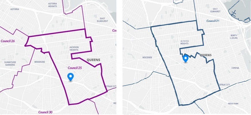
The draft map for Council District 25 (left) with the existing district map on the right. The new map would include a few extra blocks in Woodside (Source: redistrictingandyou.org)
The 30th District map, however, would undergo some change. It would see the loss of parts of Ridgewood, with that loss being made up by additional areas in Woodside.
The percentage of Hispanics and non-Hispanic whites would also be less in District 30, with the number made up for by an increase in the Asian population.
The revised District 30 would consist of 43 percent white non-Hispanic; 31 percent Hispanic; 21 percent Asian; and 2 percent Black. The current district, based on 2020 census data, would be 48 percent white non-Hispanic; 35 percent Hispanic; 12 percent Asian and 2 percent Black.
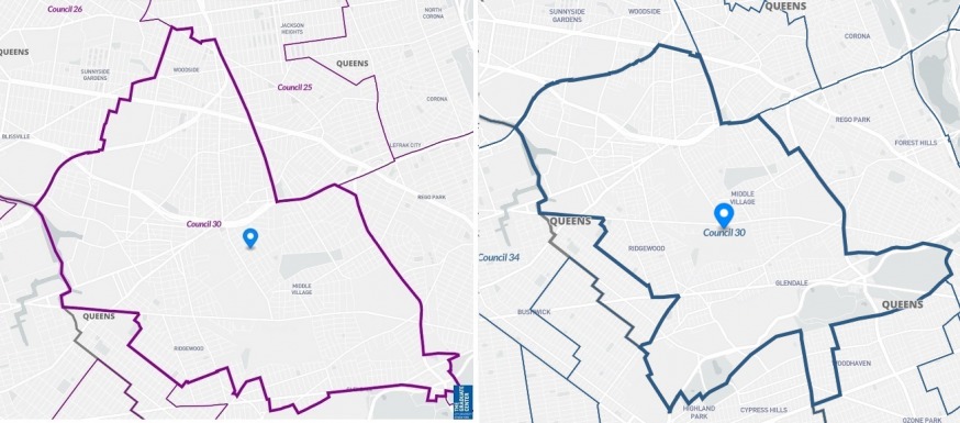
The draft map for Council District 30 (left) with the existing district map on the right. The new map would include expand deeper into Woodside, although a portion of Ridgewood would be lost (Source: redistrictingandyou.org)
However, the changes to the District 26 map are the most significant and surprising since the 15-person commission—consisting of seven appointments from the mayor, five by the council’s Democratic majority and three by the council’s Republican minority — must adhere to a number of criteria when drafting a district according to the city charter.
These include keeping neighborhoods and communities intact; keeping districts compact; limiting crossover districts (a district should not cross borough lines to the maximum extent practicable); avoiding odd-shaped districts; and not splitting voters of the same political party.
Maps that dilute the power of racial and language minorities are also prohibited.
Councilmember Julie Won, a Korean immigrant who was raised in New York, was perplexed by the map for the 26th District, which she represents.
“Looking at the preliminary council maps, it is painfully clear that no one on the NYC District Commission has read the City Charter,” Won said in a statement.
Council Member Julie Won (twitter)
“The commission chose to separate our communities of color in Long Island City, while also disenfranchising immigrant communities by splitting Woodside into four council districts.”
Won, who did say it would be “an honor to represent New Yorkers wherever they live,” added that she would be speaking out against the new map.
“I cannot stay silent while the District Commission erased the progress made by immigrants and people of color in my own neighborhood,” she said. “Members of the District Commission must be held accountable for violating every single requirement mandated by the City Charter.”
Won was not alone in questioning the makeup of the new districts.
The New York Immigration Coalition was also critical of the many of the districts drafted.
“By splitting several immigrant communities and not maintaining all of the City Council’s plurality minority districts, the NYC [Districting] Commission did not meet its mandate of keeping communities of interest together,” said Murah Awawdeh, the executive director of the coalition, said.
“The proposed district lines split up communities of color in Woodside, Ridgewood, Kensington, Richmond Hill, and the historically connected Latino communities in Red Hook and Sunset Park, making it harder for immigrant New Yorkers in these areas to elect the leaders that will represent their interests in the City Council.”
Michael Schnall, a commission member, also took issue with District 26 being split between two boroughs.
The maps, however, are by no means final and there will be a round of public hearings in August, including one in Queens.
A revised draft will then be sent to the city council in September, which it can approve or reject. Should the plan be rejected, it would prompt the commission to hold another round of public hearings.
The commission, however, would draft the final plans, regardless of the council’s position.
Council Speaker Adrienne Adams, who represents Jamaica, is urging the public to come out and weigh in on the plans.
“It is critical for the public to provide input on these first drafts as part of the ongoing redistricting process,” Adams said in a statement. “We strongly encourage all New Yorkers to participate, and we will continue working to ensure communities’ interests are prioritized and protected.”
